Conquering the Moki Dugway Road: A Comprehensive Guide to Utah’s Thrilling Switchbacks
The Moki Dugway Road, a breathtaking and somewhat intimidating stretch of dirt road in southeastern Utah, is a must-experience for adventurous travelers. Carved into the face of the Cedar Mesa, this unpaved road offers unparalleled views of Valley of the Gods and Monument Valley. But before you embark on this exciting journey, it’s essential to be prepared. This guide will provide you with everything you need to know to safely and enjoyably navigate the Moki Dugway Road.
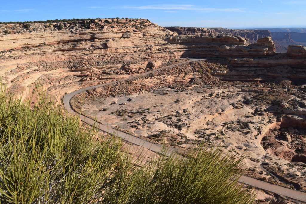
What is the Moki Dugway Road?
The Moki Dugway Road (also sometimes spelled as Moqui Dugway Road) is a 3-mile (4.8 km) section of Utah Highway 261. It descends 1,200 feet (365 m) from the top of Cedar Mesa via a series of steep, unpaved switchbacks. The road was originally constructed in the 1950s by a mining company to transport uranium ore from the Happy Jack Mine to a processing mill in Halchita, on the San Juan River. Today, it serves as a scenic route for tourists and locals alike.
Location and How to Get There
The Moki Dugway Road is located in southeastern Utah, between Mexican Hat and Natural Bridges National Monument. To reach it, take Utah Highway 261. From Mexican Hat, head north on Highway 261. The Moki Dugway Road will be clearly marked. From Natural Bridges National Monument, head south on Highway 261. Be aware that the southern end of Highway 261, leading up to the Moki Dugway Road, also includes the steep and unpaved portion known as the “Valley of the Gods Road.”
Is the Moki Dugway Road Safe?
The Moki Dugway Road can be intimidating, especially for drivers unfamiliar with steep grades and unpaved surfaces. However, with careful planning and responsible driving, it can be a safe and rewarding experience. Here are some safety tips:
- Check the Weather: Avoid driving the Moki Dugway Road in wet or snowy conditions. The road can become extremely slippery and dangerous.
- Drive Slowly: The recommended speed limit is 5 mph (8 km/h). Take your time and enjoy the scenery.
- Use Low Gear: When descending, use a low gear to control your speed and avoid overheating your brakes.
- Watch for Other Vehicles: The Moki Dugway Road is narrow and winding. Be aware of other vehicles, especially large trucks and RVs.
- Stay on the Road: The shoulders of the road are unstable. Avoid driving or parking on the shoulders.
- Be Prepared: Carry plenty of water, snacks, and a first-aid kit. Let someone know your travel plans.
What Kind of Vehicle Do You Need?
While a high-clearance vehicle is often recommended for the Moki Dugway Road, it’s not always necessary. Many passenger cars can safely navigate the road in dry conditions, provided that the driver is cautious and experienced. However, if you’re driving a low-clearance vehicle or are uncomfortable with unpaved roads, it’s best to avoid the Moki Dugway Road or consider renting a suitable vehicle. Large RVs and trailers are generally not recommended due to the tight switchbacks and steep grades. Always check current road conditions before attempting to drive the Moki Dugway Road.
What to See Along the Moki Dugway Road
The primary attraction of the Moki Dugway Road is the stunning panoramic views. From the top of Cedar Mesa, you can see for miles in every direction, including:
- Valley of the Gods: A breathtaking landscape of sandstone buttes and mesas.
- Monument Valley: The iconic landscape featured in countless Western movies.
- San Juan River: A winding river that carves its way through the desert.
- Navajo Mountain: A sacred peak for the Navajo people.
There are several pull-offs along the Moki Dugway Road where you can stop and take pictures. Be sure to take advantage of these opportunities to capture the incredible scenery. Remember to be respectful of the environment and pack out everything you pack in.
History of the Moki Dugway Road
As mentioned earlier, the Moki Dugway Road was built in the 1950s to transport uranium ore. The name “Moki” comes from the Spanish word “Moqui,” which was used to refer to the Pueblo Indians who inhabited the area. “Dugway” refers to a road built on a hillside.
Before the construction of the Moki Dugway Road, the only way to access the area was by a long and arduous route. The new road significantly reduced travel time and made it easier to transport goods and materials. While the uranium mine eventually closed, the Moki Dugway Road remained a valuable transportation route and eventually became a popular tourist attraction.
Tips for Driving the Moki Dugway Road
Here are some additional tips for driving the Moki Dugway Road:
- Start Early: The Moki Dugway Road can be crowded, especially during peak season. Starting early will help you avoid the crowds and enjoy the scenery in peace.
- Take Breaks: The Moki Dugway Road can be tiring to drive. Take frequent breaks to stretch your legs and enjoy the views.
- Be Patient: Be prepared to encounter slow-moving vehicles and occasional delays. Patience is key to a safe and enjoyable experience.
- Respect the Locals: The Moki Dugway Road is located on Navajo Nation land. Be respectful of the local culture and traditions.
- Consider a Guided Tour: If you’re not comfortable driving the Moki Dugway Road yourself, consider taking a guided tour. Several tour operators offer trips to the area.
Alternative Routes
If you’re not comfortable driving the Moki Dugway Road, there are several alternative routes you can take. You can bypass the Moki Dugway Road by taking US Highway 191 to the east or US Highway 163 to the west. However, these routes will add significant time to your journey. Another option is to drive the Valley of the Gods Road, which runs parallel to the Moki Dugway Road at the bottom of Cedar Mesa. This road is also unpaved but is generally less steep and challenging than the Moki Dugway Road. [See also: Valley of the Gods Scenic Byway]
Nearby Attractions
In addition to the Valley of the Gods and Monument Valley, there are several other attractions near the Moki Dugway Road:
- Natural Bridges National Monument: Home to three impressive natural bridges.
- Goosenecks State Park: Offers stunning views of the San Juan River as it meanders through a deep canyon.
- Forrest Gump Point: A scenic overlook on US Highway 163, made famous by the movie Forrest Gump.
- Mexican Hat Rock: A distinctive rock formation that resembles a sombrero.
Photographing the Moki Dugway Road
The Moki Dugway Road is a photographer’s paradise. The dramatic landscapes and stunning views provide endless opportunities for capturing memorable images. Here are some tips for photographing the Moki Dugway Road:
- Shoot During Golden Hour: The best time to photograph the Moki Dugway Road is during the golden hour, the hour after sunrise and the hour before sunset. The warm, soft light will enhance the colors and textures of the landscape.
- Use a Wide-Angle Lens: A wide-angle lens will allow you to capture the vastness of the landscape.
- Use a Telephoto Lens: A telephoto lens can be used to compress the distance between objects and create a sense of depth.
- Experiment with Different Angles: Don’t be afraid to experiment with different angles and perspectives. Try shooting from a low angle to emphasize the height of the buttes and mesas.
- Include People in Your Photos: Including people in your photos can help to give a sense of scale and perspective.
Conclusion
The Moki Dugway Road is an unforgettable experience. With its stunning views, thrilling switchbacks, and rich history, it’s a must-see for anyone visiting southeastern Utah. By following the tips in this guide, you can safely and enjoyably navigate the Moki Dugway Road and create memories that will last a lifetime. Remember to respect the environment, be prepared for changing conditions, and drive responsibly. The Moki Dugway Road awaits!
